AAU Herbarium Database |
| New Search Modify Search |
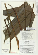
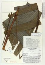
| Collector | Balslev, H. |
| Number | 62018 |
| Collected with | Henderson, A. & Borchsenius, F. |
| Country | Ecuador |
| Subpart | PICHINCHA |
| County | |
| Locality | Hda. Irena 36 km south of Santo Domingo along road to Quevedo. Remnants of moist forest. |
| Coordinates | 0° 22' S 79° 20' W |
| Minimum elevation (m) | 300 |
| Maximum elevation (m) | 300 |
| Start date | 1986/04/02 |
| End date | 1986/04/04 |
| Family | Arecaceae |
| Identification | Geonoma irena Borchs. |
| Determined by | Borchsenius, F. (AAU), 1996. |
| Identification qualifier | |
| Field notes | Cespitose, slightly procumbent. Stem 80 x 3.5 cm, nodes prominent, internodes less than a centimeter, brownish. Leaves 9, erect; sheath and petiole 100 cm, open to the base, petiole rounded below, channelled above with sharp margins between the two surfaces; rachis 105 cm long, rounded below, ridged above, glabrous; pinnae 5 - 7 per side, unevenly wide, each one with 1 - 25 primary nerves, falcate, basal pinna 48 x 4 cm, middle pinna 63 x 7.5 cm, apical pinna 47 x 14 cm. Inflorescence interfoliar, erect, simple, unbranched, spicate; peduncle 60 x 0.5 cm slightly dorsiventrally flattened; spike 36 x 1 cm. |

| |
 Other records of Geonoma irena Other records of Geonoma irenaThe map displays only records from the Aarhus Herbarium Database. The records may not represent the full distribution of Geonoma irena |
| New Search Modify Search |