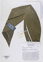
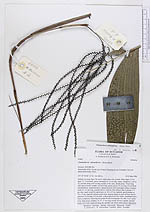
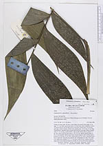
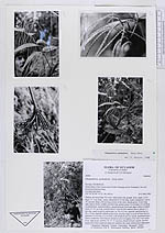
| Field notes | Solitary on steep slope. No roots visible above the ground. Stem single, 2.2 m high, 1.5 -2 cm diam., green, internodes 8 -10 cm long, nodes conspicuos. Leaves 10, inserted along a 60 cm long section of the stem; sheath green, 14 cm long, split open to below middle on lower leaf; petiole green, 10 cm long, 0.5 cm thick, rounded below, channeled above, margin between lower and upper surface rounded; rachis 37 -41 cm long, rounded below, with two flat surfaces above; pinnae 4 -5 per side, equal except for apical pair, ca. 28 x 6.5 cm, sigmoid, apical pinnae ca. 32 x 13 cm, sigmoid. Inflorescences four, inserted singly in axils of lower leaves; peduncle 32 cm long, 0.5 cm wide, with prophyll and five sterile, sheathing bracts; bracts completely encircling the peduncle and overtopping it by only 5 cm; rachis 6 cm, light green; rachillae 14, 15 -17 cm long; female flowers cupular, inserted singly and evenly dispersed along the rachillae; the whole inflorescence light green. |