AAU Herbarium Database |
| New Search Modify Search |
| Collector | Balslev, H. |
| Number | 6200 |
| Collected with | Hall, P. |
| Country | Ecuador |
| Subpart | NAPO |
| County | |
| Locality | Yasuni Scientific Research Station, Monkey trail system, km 44 on Pompeya-Tivacuno road. Tropical rainforest - terra firme. |
| Coordinates | 0° 40' S 76° 23' W |
| Minimum elevation (m) | 230 |
| Maximum elevation (m) | 230 |
| Start date | 1995/07/26 |
| End date | 1995/07/26 |
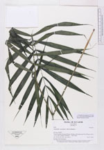
| Family | Arecaceae |
| Identification | Ammandra decasperma O.F.Cook |
| Determined by | H. Balslev |
| Identification qualifier | |
| Field notes | Seedling. Flat bottomland. |
| |
 Other records of Ammandra decasperma Other records of Ammandra decaspermaThe map displays only records from the Aarhus Herbarium Database. The records may not represent the full distribution of Ammandra decasperma |
| New Search Modify Search |