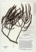
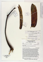
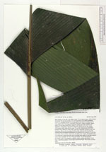
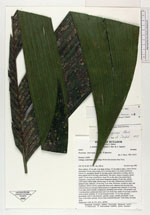
| Field notes | Stem solitary, 4.3 m tall, 4 cm diam at base, 3.5 cm diam at apex, yellow brown; internodes 4-6 cm long at base, 0.5-1 cm long above 2 m; nodes prominent. Leaves 11, spreading; sheath 15 cm long, green with brown covering, open to base; petiole 40-50 cm long, round below, flat above, sharp at margins, green; rachis 135 cm long, round below, basal 50 cm flat above but narrowing to triangular, young rachis with brown tomentum; pinnae 6-8 per side, falcate, 2-20-veined; whole blade 160 cm long, 55 cm wide. Inflorescence infrafoliar; prophyll early caducous, 20 cm long, 6 cm wide, bicarinate, rounded at apex and acuminate, fibrous, brown; peduncular bract early caducous and not seen (one collected from an immature inflorescence of a separate tree); peduncle 23 cm long, 2 cm wide, dorsoventrally compressed, sheathing stem at base, with prophyll scar 1 cm from base, peduncular bract scar 4 cm from base; rachis 35 cm long, round in cross-section; rachillae 18, 43 cm long proximally, 15 cm long apically, proximally with 12 side branches, apically simple, reddish, proximally 12 cm long, 4 mm thick, apically, flower buds exserted from pits. Terra firme, on steep slope. Duplicates: AAU, K, NY, QCA, QCNE. |
 Other records of Geonoma interrupta var. interrupta