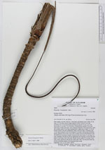
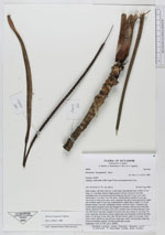
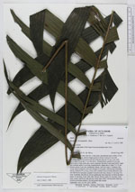
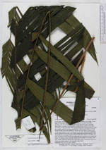
| Field notes | Stem solitary, the base with few, 2 mm thick, adventitious roots visible, 55 cm long, 2.5-3 cm diam, densely ringed, green to brown. Leaves 8, erect and spreading, base of lowermost leaf encircling the stem for 0.5 cm, 3 cm wide, narrowing to 1 cm after 5 cm, flat above, rounded below; petiole 45 cm long, narrowing to 4 mm at the apex, green, basal part flat above and round below, upper part rounded; rachis 55 cm long, rounded below, ridged above; blade 75 x 55 cm, pinnate; pinnae 9 per side, reduplicate, falcate, each one with 2-10 primary ribs, evenly spaced along the rachis and arranged in one plane. Inflorescense infrafoliar, spicate, peduncle 30 cm long, 4 mm wide, rounded, dorsoventrally flattened, wine red with brown tomentum; prophyll inserted at the base, linear; 21 cm long, 9 m wide, bicarinate, thin fibrous, brown; peduncular bract inserted 4 cm from the base, linear, 21 cm long, 8 mm wide, thin, fibrous, brown; rachis 23 cm long, 5 mm wide, round, with flower pits all way round, apex with 5 cm long thin sterile tip, flowers at pistillate anthesis. On flat ground near a creek. Duplicates: AAU, K, NY, QCA, QCNE. |