AAU Herbarium Database |
| New Search Modify Search |
| Collector | Balslev, H. |
| Number | 60592 |
| Collected with | Barfod, A. & Skov, F. |
| Country | Ecuador |
| Subpart | NAPO |
| County | |
| Locality | Añangu, south bank of Río Napo 95 km downstream from Coca. |
| Coordinates | 0° 32' N 76° 23' W |
| Minimum elevation (m) | 300 |
| Maximum elevation (m) | 300 |
| Start date | 1985/06/19 |
| End date | 1985/07/04 |
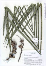
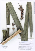
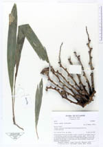
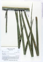
| Family | Arecaceae |
| Identification | Attalea maripa (Aubl.) Mart. |
| Determined by | (H. Balslev, 1994) |
| Identification qualifier | |
| Field notes | Juvenile palm in forest on terra firme. Trunk c. 2 m tall, 30 cm in diam. Crown of c. 10 erect leaves; petiole 5.4 m long, rounded abaxially; blade c. 10 x 2 m, with 2x 180 pinnae arranged in 50 groups of 3-5 pinnae each; the pinnae 120 cm long, diverging from the rachis in various directions. Parts of old infru- tescence from fallen part of neighbouring tree. |
| |
 Other records of Attalea maripa Other records of Attalea maripaThe map displays only records from the Aarhus Herbarium Database. The records may not represent the full distribution of Attalea maripa |
| New Search Modify Search |