AAU Herbarium Database |
| New Search Modify Search |
| Collector | Balslev, H. |
| Number | 60517 |
| Collected with | Barfod, A. & Skov, F. |
| Country | Ecuador |
| Subpart | NAPO |
| County | |
| Locality | Añangu, south bank of Río Napo 95 km downstream from Coca. |
| Coordinates | 0° 32' N 76° 23' W |
| Minimum elevation (m) | 300 |
| Maximum elevation (m) | 300 |
| Start date | 1985/06/19 |
| End date | 1985/07/04 |
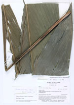
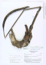
| Family | Arecaceae |
| Identification | Geonoma macrostachys var. macrostachys Mart. |
| Determined by | F. Skov, 1989 (AAU). |
| Identification qualifier | |
| Field notes | Giant rosettes of up to 10 leaves, each leaf up to 2 m long, erect. Inflorescence originating in axil of basal leaves, erect or bending slightly outwards, colour first grey-green, then orange, fruits green turning black. On terra firme, lateritic soil. Collector on label: F. Skov & K. Petersen |
| |
| Display all 220 georeferenced records of Geonoma Geonoma macrostachys var. macrostachys |
| New Search Modify Search |