AAU Herbarium Database |
| New Search Modify Search |
| Collector | Balslev, H. |
| Number | 4869 |
| Collected with | |
| Country | Ecuador |
| Subpart | NAPO |
| County | |
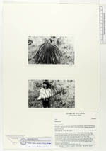
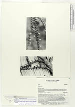
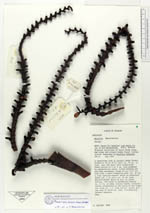
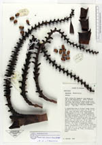
| Locality | Along Río Aguarico just below inlet of Río Shushufindi. Tropical rain forest on terra firme along the river and primary swamp forest further inland, dominated by Mauritia flexuosa. |
| Coordinates | 0° 18' S 76° 20' W |
| Minimum elevation (m) | 300 |
| Maximum elevation (m) | 300 |
| Start date | 1984/02/20 |
| End date | 1984/02/20 |
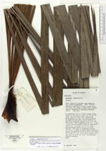
| Family | Arecaceae |
| Identification | Mauritiella armata (Mart.)Burret |
| Determined by | Borchsenius,F. |
| Identification qualifier | |
| Field notes | A caespitose tree in primary swamp forest. Trunks to 20 or 25 m tall, ca 30 cm in diam near the base, with conspicuous brown spines to 3 or 5 cm long produced by adventitious roots, trunks bending out and then ascending. Crown of ca 6-10 leaves, each with a short sheathing part (ca 10 cm) a long petiole-sheath which is channeled above (ca 1 m) and a ca 30 cm long petiole-proper which is oval in cross-section; the blade is palmeately nerved ca 2.5 m in diam, silvery below. Inflorescences originating in the axils of the lower leaves with ca 2 m long central rachis giving rise to 30-60 cm long, fruitbearing lateral branches. Duplicates: QCA, QCNE, Latinreco, NY, AAU, K. |
| |
 Other records of Mauritiella armata Other records of Mauritiella armataThe map displays only records from the Aarhus Herbarium Database. The records may not represent the full distribution of Mauritiella armata |
| New Search Modify Search |