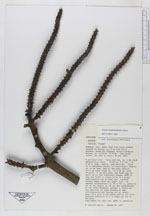
| Field notes | (G. sp. aff. weberbaueri). Spanish: "Palma". A solitary tree. Base with red, ca 5 mm diam, adventitious roots. Trunk ca 5 m tall, ca 9 cm diam, smooth, greyish-brown. Crown of 12 spreading leaves; no crownshaft; sheaths ca 40 cm long, open; petiole 10-15 cm long; blade ca 150x80 cm; with 50 "plica" on each side, these not all split up to form individual pinnae, but rather fused in groups of up to 8. Inflorescence one on each tree, inserted several nodes below the lowest leaf, the largest inflorescence to 130 x 100 cm, peduncle ca 50 cm, rachis ca 60 cm, sidebranches to 2 times branched; spathes 2, dehiscing but remaining as loose sheaths on some inflorescences, falling off on others. Uses: This palm is not being used according to a 16 year old boy of the area. |
 Other records of Geonoma weberbaueri