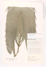
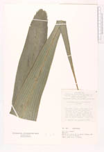
| Collector | Balslev, H. |
| Number | 3046 |
| Collected with | |
| Country | Ecuador |
| Subpart | NAPO |
| County | |
| Locality | Laguna Jatuncocha ca 60 km south west of Nueva Roca fuerte. Island with terra firme and blackwater "pantano" swamp forest. Etnobotanical information by Sr. Abel Greja and Sra. de Flavio Cabrera. |
| Coordinates | 1° 0' S 75° 27' W |
| Minimum elevation (m) | 200 |
| Maximum elevation (m) | 200 |
| Start date | 1982/09/01 |
| End date | 1982/09/01 |
| Family | Arecaceae |
| Identification | Attalea maripa (Aubl.) Mart. |
| Determined by | H. Balslev |
| Identification qualifier | |
| Field notes | Stemless palm in virgin forest. Young leaves entire. Oled? leaves divided. |
|
 Other records of Attalea maripa