AAU Herbarium Database |
| New Search Modify Search |
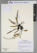
| Collector | Balslev, H. |
| Number | 11679 |
| Collected with | Manop Poopath, Natcha Sutjaritjai, Wirata Rujichaipimon, Pornchai Kladowong, Preecha Karaket, Sukid Ruengruea, Tanawat Teeranan, Kunanon Daonurai, Kanitima Suwannawat, Theerawat Thonanthaisong, Yosita Sattasen, Watcharin Puntunakin, Manus Yisarkun, Wittawat Sriprasom, Stella Sylva. |
| Country | Thailand |
| Subpart | Trat |
| County | |
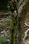
| Locality | Koh Chang archipelago. Koh Lao Ya Nai island 15-20 km Salak Pet village. Hill island with narrow plain dry coast. Sandy beach with Terminalia catappa and Cocos nucifera. Resort buildings empty but not abandoned. |
| Coordinates | 11° 56' 34'' N 102° 24' 25'' E |
| Minimum elevation (m) | 0 |
| Maximum elevation (m) | 0 |
| Start date | 2024/05/22 |
| End date | 2024/05/22 |
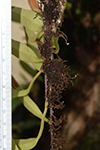
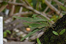
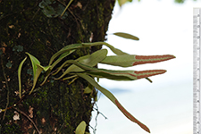
| Family | Polypodiaceae |
| Identification | Pyrrosia |
| Determined by | |
| Identification qualifier | |
| Field notes | Epiphyte on Hibiscus |

| |
 Other records of Pyrrosia Other records of PyrrosiaThe map displays only records from the Aarhus Herbarium Database. The records may not represent the full distribution of Pyrrosia |
| New Search Modify Search |