AAU Herbarium Database |
| New Search Modify Search |
| Collector | Pedersen, H. B. |
| Number | 97615 |
| Collected with | |
| Country | Ecuador |
| Subpart | PASTAZA |
| County | |
| Locality | North of Rio Pastaza, near the Achuar village of Mashient, SW of Copataza. Along trail through primary forest. |
| Coordinates | 1° 3' S 78° 54' W |
| Minimum elevation (m) | 500 |
| Maximum elevation (m) | 500 |
| Start date | 1990/10/04 |
| End date | 1990/10/04 |
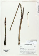
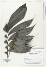
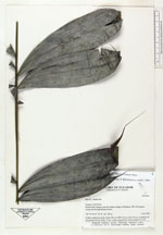
| Family | Arecaceae |
| Identification | Bactris maraja var. maraja Mart. |
| Determined by | F. Borchsenius |
| Identification qualifier | |
| Field notes | Solitary understory palm. Stem 235 cm, DBH 2.0 cm with 5 leaves. Leafsheat 30 cm; petiole 40 cm; rachis 75 cm, pinnae sigmodoid, in four groups (2,3,3,5) |
| |
| Display all 55 georeferenced records of Bactris Bactris maraja var. maraja |
| New Search Modify Search |