AAU Herbarium Database |
| New Search Modify Search |
| Collector | Pedersen, H. B. |
| Number | 97604 |
| Collected with | Foster, R. & Plotkin, M. |
| Country | Ecuador |
| Subpart | ESMERALDAS |
| County | |
| Locality | Between Rio Santiago and Rio Cayapa near the village of Valdez (at Estero María), on trail to Cerro La Tunda. Old growth forest. |
| Coordinates | 1° 3' N 78° 55' W |
| Minimum elevation (m) | 30 |
| Maximum elevation (m) | 30 |
| Start date | 1990/09/04 |
| End date | 1990/09/04 |
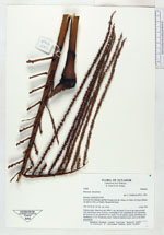
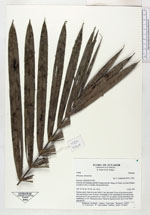
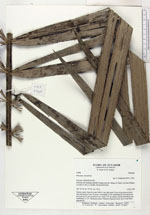
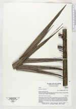
| Family | Arecaceae |
| Identification | Prestoea decurrens (H.Wendl. ex Burret) H.E.Moore |
| Determined by | A. Henderson (NY), 1992. |
| Identification qualifier | |
| Field notes | Solitary palm. Stem 6 m tall, DBH: 5 cm, the basal 10 cm of the stem covered with adventitous roots. 8 leaves, crownshaft 95 cm, leafsheath 85 cm (encircling the stem for 45 cm), petiole 65 cm, rachis 275 cm, pinnae equally distributed and numbering 2 x 54. Vernacular name: Palmichi (Spanish name used by the black population). |
| |
 Other records of Prestoea decurrens Other records of Prestoea decurrensThe map displays only records from the Aarhus Herbarium Database. The records may not represent the full distribution of Prestoea decurrens |
| New Search Modify Search |