AAU Herbarium Database |
| New Search Modify Search |
| Collector | Pedersen, H. B. |
| Number | 171 |
| Collected with | Birgitte Bergmann & James L. Luteyn |
| Country | Ecuador |
| Subpart | IMBABURA |
| County | |
| Locality | Road dto IETEL antennas (sideroad from Otavalo-San José de Minas road, leaving the Otavalo-San José de Minas road shortly after the San José de mInas road leaves the Otavalo-Selva Alegre road). Primary humid forest. Canopy at 6-10 m. |
| Coordinates | 0° 14' N 78° 22' W |
| Minimum elevation (m) | 3700 |
| Maximum elevation (m) | 3700 |
| Start date | 1989/10/09 |
| End date | 1989/10/17 |
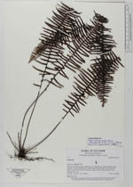
| Family | Polypodiaceae |
| Identification | Mycopteris semihirsuta (Klotzsch) Sundue |
| Determined by | M. Sundue |
| Identification qualifier | |
| Field notes | Epiphytic fern. |
| |
| Display all 37 georeferenced records of Mycopteris Mycopteris semihirsuta |
| New Search Modify Search |