AAU Herbarium Database |
| New Search Modify Search |
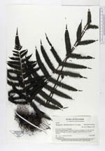
| Collector | Pedersen, H.B. |
| Number | 104307 |
| Collected with | et al. |
| Country | Ecuador |
| Subpart | Zamora-Chinchipe |
| County | |
| Locality | Estacion Experimental “El Padmi”, Zamora-Gualaquiza rd. km 60, just South of El Pangui. Secondary vegetation between the road and rio Zamora |
| Coordinates | 3° 40' S 78° 33' W |
| Minimum elevation (m) | 800 |
| Maximum elevation (m) | 800 |
| Start date | 1995/06/05 |
| End date | 1995/06/05 |
| Family | Thelypteridaceae |
| Identification | Thelypteris dentata (Forssk.)E. St. John |
| Determined by | Øllgaard,B. |
| Identification qualifier | |
| Field notes | Terrestrial fern |
| |
 Other records of Thelypteris dentata Other records of Thelypteris dentataThe map displays only records from the Aarhus Herbarium Database. The records may not represent the full distribution of Thelypteris dentata |
| New Search Modify Search |