AAU Herbarium Database |
| New Search Modify Search |
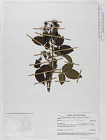
| Collector | Pedersen, H. B. |
| Number | 104088 |
| Collected with | Z. Aguirre & N. Aguirre. |
| Country | Ecuador |
| Subpart | LOJA |
| County | |
| Locality | Disturbed forest around antennas on exposed hilltop above the village of Guachanama (North of Celica) |
| Coordinates | 4° 2' S 79° 54' W |
| Minimum elevation (m) | 2900 |
| Maximum elevation (m) | 2900 |
| Start date | 1994/08/24 |
| End date | 1994/08/24 |
| Family | Rosaceae |
| Identification | Rubus peruvianus Fritsch |
| Determined by | K. Romoleroux (QCA) 1996, S.Laegaard (AAU) 2008 |
| Identification qualifier | |
| Field notes | . |
| |
 Other records of Rubus peruvianus Other records of Rubus peruvianusThe map displays only records from the Aarhus Herbarium Database. The records may not represent the full distribution of Rubus peruvianus |
| New Search Modify Search |