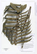
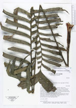
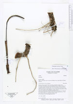
| Field notes | Solitary understory palm. Stem 17 cm long, decumbent, rough, brown, rhizom-like. Adventitous roots found troughout the stem. Diameter at base: 4.0 cm., diameter below lowermost leaf: 3.8 cm. No. of leaves: 8. Leaves fernlike. Leafsheat + petiole: 56 cm long. Basic 3 cm. of the leafsheat encircling the stem. Petiole almost circular with a diameter of 0.6 cm. below lowermost pinnae. Rachis 78 cm. No. of pinnae: 2x26, alternating, regularly inserted. Inflorescence: One, spicate, inserted in first node below lowermost leaf. Peduncle 22 cm. long. Prophyl 4.5 cm long, persistent. First peduncular bract ca. 13 cm long. Rachis 14 cm long, with flowers sunken in pits. the 4 lowermost leaves each supporting one bud. AAU, QCA, QCNE. org. no. AAU 67307 |