AAU Herbarium Database |
| New Search Modify Search |
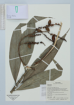
| Collector | Villa, G. |
| Number | 1479 |
| Collected with | P. Alvia, A. Moscoso, J. Santiana y E. Roblez |
| Country | Ecuador |
| Subpart | Francisco De Orellana |
| County | |
| Locality | Estacion Cientifica Yasuni. Río Tiputini, al noroeste de la confluencia con el R. Tivacuno; Este de la carretera Repsol-YPF, km 7 desvío hacia el pozo Tivacuno. A 400 m aguas abajo de la ECY, orilla izquierda del río. Plano inundable, lomas de 30-50 m, de arcilla rojiza. |
| Coordinates | 0° 38' S 76° 30' W |
| Minimum elevation (m) | 200 |
| Maximum elevation (m) | 300 |
| Start date | 2002/04/28 |
| End date | 2002/04/28 |
| Family | Arecaceae |
| Identification | Desmoncus |
| Determined by | |
| Identification qualifier | |
| Field notes | Liana trepadora a 7 m, con frutos en racimos grandes de color amarillo a rojo. |
| |
 Other records of Desmoncus Other records of DesmoncusThe map displays only records from the Aarhus Herbarium Database. The records may not represent the full distribution of Desmoncus |
| New Search Modify Search |