AAU Herbarium Database |
| New Search Modify Search |
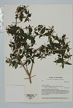
| Collector | Lewis, G.P. |
| Number | 3639 |
| Collected with | B.B.Klitgaard & A.Bruneau |
| Country | Ecuador |
| Subpart | Pichincha |
| County | |
| Locality | Track from Lloa to Guagua Pichincha, km 5; W of Quito. Vegetation: secondary scrub and cultivation. |
| Coordinates | 0° 12' S 78° 40' W |
| Minimum elevation (m) | 3950 |
| Maximum elevation (m) | 3950 |
| Start date | 1997/10/09 |
| End date | 1997/10/09 |
| Family | Solanaceae |
| Identification | Jaltomata |
| Determined by | Andres Orejuela |
| Identification qualifier | |
| Field notes | Scandent shrub; leaves membranaceus, rugose, dark green; pedicels and midvein of calyx lobes black, calyces mid-green, petals pale green wirh dark veins, filaments white, anthers cream; fruits globose, pale greenish yellow with darker green veins. In hedge row. Apparently are but possibly introduced. |
| |
 Other records of Jaltomata Other records of JaltomataThe map displays only records from the Aarhus Herbarium Database. The records may not represent the full distribution of Jaltomata |
| New Search Modify Search |