AAU Herbarium Database |
| New Search Modify Search |
| Collector | Lewis, G.P. |
| Number | 3445 |
| Collected with | B.Merino % N. Aguirre |
| Country | Ecuador |
| Subpart | Azuay |
| County | |
| Locality | 21 km SE of Troncal, track from Zuchay to Manta Real, 2.5 o 3.5 km above Manta Real, above Río Patúl. Bosque humedo tropical |
| Coordinates | 2° 34' S 79° 21' W |
| Minimum elevation (m) | 500 |
| Maximum elevation (m) | 500 |
| Start date | 1997/08/13 |
| End date | 1997/08/13 |
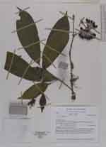
| Family | Annonaceae |
| Identification | Guatteria microcarpa Ruiz & Pav. |
| Determined by | P.J.M.Maas & L.Y.Th.Westra |
| Identification qualifier | |
| Field notes | Scandent shrub, pendent from 3-4 m; leaves dark green, glossy, slightly darker above; pedicels dark purplish red, sepals and petals pale greenish yellow, anthers dark diety yellow, stigma green; fruits hard, ellipsoid, dark olive-green maturing purple-black. Uncommen |
| |
 Other records of Guatteria microcarpa Other records of Guatteria microcarpaThe map displays only records from the Aarhus Herbarium Database. The records may not represent the full distribution of Guatteria microcarpa |
| New Search Modify Search |