AAU Herbarium Database |
| New Search Modify Search |
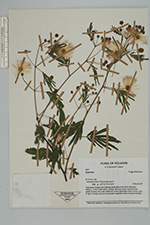
| Collector | Lewis, G.P. |
| Number | 3037 |
| Collected with | P. Lozano |
| Country | Ecuador |
| Subpart | Loja |
| County | |
| Locality | Yaramine, track to Sozoranga, km 2 |
| Coordinates | 4° 20' S 79° 47' W |
| Minimum elevation (m) | 1700 |
| Maximum elevation (m) | 1700 |
| Start date | 1997/03/05 |
| End date | 1997/03/05 |
| Family | Fabaceae |
| Identification | Zapoteca |
| Determined by | |
| Identification qualifier | |
| Field notes | Vegetation: bosque seco espinoso, secondary scrub and cultivation. Shrub, 1-2 m x 3 mm diam., whispy flexuous stems; leaflets bluish green; flowers very pale yellowish cream, filaments white at base, pink at apex. Locally common in secondary vegetation and on bosque margins |
| |
 Other records of Zapoteca Other records of ZapotecaThe map displays only records from the Aarhus Herbarium Database. The records may not represent the full distribution of Zapoteca |
| New Search Modify Search |