AAU Herbarium Database |
| New Search Modify Search |
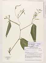
| Collector | Lewis, G.P. |
| Number | 2833 |
| Collected with | B. Merino P. Lozano, B. Ollgaard & A. Ollgaard |
| Country | Ecuador |
| Subpart | El Oro |
| County | |
| Locality | Road Pinas - Santa Rosa, track to Zambotambo, km 4.5. |
| Coordinates | 79° 48' W 3° 37' S |
| Minimum elevation (m) | 1050 |
| Maximum elevation (m) | 1050 |
| Start date | 1996/11/19 |
| End date | 1996/11/19 |
| Family | Marantaceae |
| Identification | Stromanthe |
| Determined by | S. Vieira |
| Identification qualifier | |
| Field notes | Vegetation: much disturbed bosque humedo ( low montane forest) near river.Herb, 1.5 m; leaves discolorous, + glossy, dark green above, paler below; bracts mid-green glossy, calyces very pale yellowish green with a fleshy, rugose orange base (=fruit), petals white; mature fruit fleshy, glossy, scarlet. Locally common. |
| |
 Other records of Stromanthe Other records of StromantheThe map displays only records from the Aarhus Herbarium Database. The records may not represent the full distribution of Stromanthe |
| New Search Modify Search |