| Collector | Lewis, G. P. |
| Number | 2654 |
| Collected with | P. Lozano, N. Aguirre & I. Aldaz |
| Country | Ecuador |
| Subpart | El Oro |
| County | |
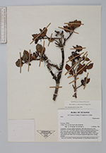
| Locality | Chilla, 7 km up dirt road to the Antennas. (Location: 79°36'243''W;3°27'964''S). Vegetation: bosque nublado transition with elfin ericaceous scrub. |
| Coordinates | 3° 27' S 79° 36' W |
| Minimum elevation (m) | 2920 |
| Maximum elevation (m) | 2920 |
| Start date | 1996/10/04 |
| End date | 1996/10/04 |
| Family | Myrtaceae |
| Identification | Myrcianthes orthostemon (O.Berg) Grifo |
| Determined by | M.L. Kawasaki & B.K. Holst |
| Identification qualifier | cf. |
| Field notes | Shrub 1.5 - 2 m x 2 cm diam.; leaves coriaceous, dark green glossy above, pale yellowish green and dull below; calyces green tinged purplish black; petals white, filaments white, anthers pale yellow, ovary red, style pinkish red. Open area on bosque margin amongst rocks. Locally common. |
|
 Other records of Myrcianthes orthostemon