AAU Herbarium Database |
| New Search Modify Search |
| Collector | Lewis, G.P. |
| Number | 2435 |
| Collected with | P.Klitgaard |
| Country | Ecuador |
| Subpart | Loja |
| County | |
| Locality | Road Loja to Cuenca, km 12, c. 18 km S of Santiago. Bosqeu húmedo remnant with surroundingh pastureland. |
| Coordinates | 3° 55' S 79° 13' W |
| Minimum elevation (m) | 2400 |
| Maximum elevation (m) | 2500 |
| Start date | 1996/07/11 |
| End date | 1996/07/11 |
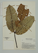
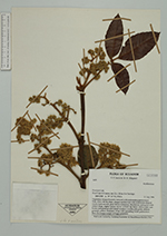
| Family | Brunelliaceae |
| Identification | Brunellia Ruiz & Pav. |
| Determined by | Dr. Pete Lowry |
| Identification qualifier | |
| Field notes | Treelet, 10 m x 40 cm diam., elegant architecture with mushroom-shaped crown, bark smooth, grey; leaves coriaceous, discolorous, mid-green with yellow tinge, slighty glossy above, withsih tan below with a pale rust-brown indumentum and raised venation; corollas pale green, anthers greenish yellow, filaments white with spreading white pubescence. Rare. On bosque margin in boggy grassland. |
| |
 Other records of Brunellia Other records of BrunelliaThe map displays only records from the Aarhus Herbarium Database. The records may not represent the full distribution of Brunellia |
| New Search Modify Search |