AAU Herbarium Database |
| New Search Modify Search |
| Collector | Galeano, G. |
| Number | 8227 |
| Collected with | H. Balslev, I.L. Olivares, J. Carreño, J.C. Copete, D. Jiménez, S. Valenciá & L.A. Núñez |
| Country | Colombia |
| Subpart | Valle del Cauca |
| County | |
| Locality | 20 km NW of Buenaventura, 13 km ENE of Bahía Málaga naval base. La Plata. La Calita de Paula. Wet tropical rainforest on hills behind mangrove. |
| Coordinates | 3° 59' 52.1'' N 77° 12' 43.26'' W |
| Minimum elevation (m) | 31 |
| Maximum elevation (m) | 0 |
| Start date | 2011/08/00 |
| End date | 2011/08/00 |
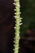
| Family | Arecaceae |
| Identification | Geonoma paradoxa Burret |
| Determined by | G.Galeano (COL) & H.Balslev (AAU) |
| Identification qualifier | |
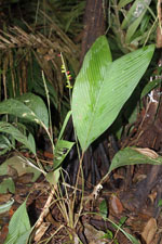
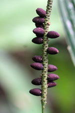
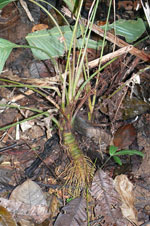
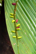
| Field notes | Solitary understory palm. Stem 1.5 m long, 4 cm thick, green, prostrate. Leaves 5; sheath 8 cm long; petiole 36 cm long; rachis 33 cm long, with a thick brown indumentum below; lamina entire, flat, 42 cm long, 22 cm wide. Inflorescence/infructescence interfoliar; prophyll 7.5 cm long; peduncular bract 15 cm long; peduncle 53-60 cm long; spike 14-18 cm long, 1 cm thick, green. Flowers white. Fruits ovoid-oblong, 1.5 cm long, 0.9 cm wide, purple. Transect: HB 1055 |

| |
 Other records of Geonoma paradoxa Other records of Geonoma paradoxaThe map displays only records from the Aarhus Herbarium Database. The records may not represent the full distribution of Geonoma paradoxa |
| New Search Modify Search |