AAU Herbarium Database |
| New Search Modify Search |
| Collector | Galeano, G. |
| Number | 8220 |
| Collected with | H. Balslev, I.L. Olivares, J. Carreño, J.C. Copete, D. Jiménez, S. Valenciá & L.A. Núñez |
| Country | Colombia |
| Subpart | Valle del Cauca |
| County | |
| Locality | 21 km NW of Buenaventura, 17 km ENE of Bahía Málaga naval base. La Plata. La Calita de Paula. Wet tropical rainforest on hills behind mangrove. |
| Coordinates | 4° 2' 12.33'' N 77° 11' 33.31'' W |
| Minimum elevation (m) | 25 |
| Maximum elevation (m) | 0 |
| Start date | 2011/08/00 |
| End date | 2011/08/00 |
| Family | Arecaceae |
| Identification | Desmoncus cirrhifera Gentry & Zardini |
| Determined by | G.Galeano (COL) & H.Balslev (AAU) |
| Identification qualifier | |
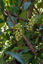
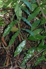
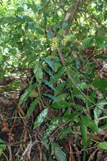
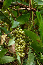
| Field notes | Liana. Stem 1.5 cm thick. Leaves numerous; sheath 34 cm long, closed, with 0.5 cm long green spines; petiole 10 cm long, with 0.5 cm long green spines; rachis 128 cm long, with 0.5 cm long green spines; lamina pinnate; pinnae 10 per side; basal pinna 22 cm long, 4.5 cm wide, middle pinna 25 cm long, 6.1 cm wide, apical pinna 17 cm long, 3.5 cm wide. Infructescence interfoliar; prophyll 20 cm long, 2.5 cm wide; peduncle 35 cm long; rachis 15 cm long, rachillae 16, 1.7-6 cm long. Fruits green, 2 cm long, 1.2 cm wide. Transect: HB 1054, subunit no. 14 |
| |
 Other records of Desmoncus cirrhifera Other records of Desmoncus cirrhiferaThe map displays only records from the Aarhus Herbarium Database. The records may not represent the full distribution of Desmoncus cirrhifera |
| New Search Modify Search |