AAU Herbarium Database |
| New Search Modify Search |
| Collector | Galeano, G. |
| Number | 8216 |
| Collected with | H. Balslev, I.L. Olivares, J. Carreño, J.C. Copete, D. Jiménez, S. Valenciá & L.A. Núñez |
| Country | Colombia |
| Subpart | Valle del Cauca |
| County | |
| Locality | 23 km WNW of Buenaventura, 8 km E of Bahía Málaga naval base. La Plata. Alingal. Wet tropical rainforest on hills behind mangrove. |
| Coordinates | 3° 58' 29.98'' N 77° 15' 25.25'' W |
| Minimum elevation (m) | 64 |
| Maximum elevation (m) | 0 |
| Start date | 2011/08/00 |
| End date | 2011/08/00 |
| Family | Arecaceae |
| Identification | Bactris hondurensis Standl. |
| Determined by | G.Galeano (COL) & H.Balslev (AAU) |
| Identification qualifier | cf. |
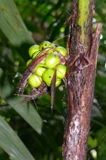
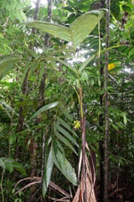
| Field notes | Leaves 4-5 per stem; sheath 38 cm long, open, with 1 cm long black spines; petiole 19 cm long, section round, with 10 cm long spines; rachis 56 cm long; lamina pinnate, flat; pinnae 5-6 per side, insertion regular; basal pinna 46 cm long, 4 cm wide, middle pinna 45 cm long, 4 cm wide, apical pinna 47 cm long, 14 cm wide. Infructescence interfoliar; peduncle 5 cm long, 1.5 cm wide; rachillae 5. Fruits green, 2.5 cm long, 2 cm wide. Local name: Chascarrá. No uses. Transect: HB 1053, subunit no. 34 |
| |
 Other records of Bactris hondurensis Other records of Bactris hondurensisThe map displays only records from the Aarhus Herbarium Database. The records may not represent the full distribution of Bactris hondurensis |
| New Search Modify Search |