AAU Herbarium Database |
| New Search Modify Search |
| Collector | Galeano, G. |
| Number | 8191 |
| Collected with | H. Balslev, I.L. Olivares, J. Carreño, J.C. Copete, D. Jiménez, S. Valenciá & L.A. Núñez |
| Country | Colombia |
| Subpart | Valle del Cauca |
| County | |
| Locality | 23 km NW of Buenaventura, 18 km NE of Bahía Málaga naval base. La Plata. La Zanja. Wet tropical rainforest on hills behind mangrove. |
| Coordinates | 4° 3' 41.173'' N 77° 11' 12.194'' W |
| Minimum elevation (m) | 21 |
| Maximum elevation (m) | 21 |
| Start date | 2011/08/21 |
| End date | 2011/08/21 |
| Family | Arecaceae |
| Identification | Bactris coloradonis L.H.Bailey |
| Determined by | G.Galeano (COL) & H.Balslev (AAU) |
| Identification qualifier | |
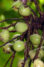
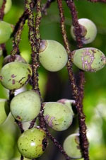
| Field notes | Colonial midstory palm with 4 stems. Stems 2-3 m high, 3.5 cm thick. Leaves 6 per stem; sheath 80 cm long, open; petiole 62 cm long, section round, with a thick light brown indumentum; rachis 165 cm long, with a brown indumentum and scattered spines; lamina pinnate; pinnae 22 per side, inserted in groups of 2-4; basal pinna 44 cm long, 3.5 cm wide, middle pinna 64 cm long, 7 cm wide, apical pinna 21 cm long, 6 cm wide. Infructescence interfoliar; peduncular bract 35 cm long, brown, with 1.2 cm long dark brown spines; peduncle 15 cm long, with 0.5 cm long dark brown spines; rachis 6 cm long; rachillae 28, 17-22 cm long. Fruits green, obovoid. Transect: HB 1050 |
| |
 Other records of Bactris coloradonis Other records of Bactris coloradonisThe map displays only records from the Aarhus Herbarium Database. The records may not represent the full distribution of Bactris coloradonis |
| New Search Modify Search |