AAU Herbarium Database |
| New Search Modify Search |
| Collector | Galeano, G. |
| Number | 8182 |
| Collected with | H. Balslev, I.L. Olivares, J. Carreño, J.C. Copete, D. Jiménez, S. Valenciá & L.A. Núñez |
| Country | Colombia |
| Subpart | Valle del Cauca |
| County | |
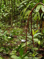
| Locality | 33 km NW of Buenaventura, 18 km NNE of Bahía Málaga naval base. La Plata. Quebrada Alegría. Wet tropical rainforest on hills behind mangrove. |
| Coordinates | 4° 7' 2.962'' N 77° 15' 12.519'' W |
| Minimum elevation (m) | 14 |
| Maximum elevation (m) | 14 |
| Start date | 2011/08/19 |
| End date | 2011/08/19 |
| Family | Arecaceae |
| Identification | Pholidostachys pulchra H. Wendl. ex Burret |
| Determined by | |
| Identification qualifier | |
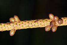
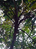
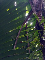
| Field notes | Solitary midstory palm. Stem 4 m high, 5.5 cm thick. Leaves 14; sheath 59 cm long, open; petiole 104 cm long, section margined; rachis 156 cm long; lamina pinnate, flat; pinnae 9-11 per side; basal pinna 75 cm long, 14 cm wide, middle pinna 77 cm long, 12 cm wide, apical pinna 64 cm long, 38 cm wide. Infructescence interfoliar, covered by indumentum; peduncle 42 cm long, 2 cm wide; rachillae 2, 71-75 cm long, 1.5 cm wide. Silica gel sample taken. Transect: HB 1048, subunit no. 68 |
| |
 Other records of Pholidostachys pulchra Other records of Pholidostachys pulchraThe map displays only records from the Aarhus Herbarium Database. The records may not represent the full distribution of Pholidostachys pulchra |
| New Search Modify Search |