| Collector | Galeano, G. |
| Number | 8181 |
| Collected with | H. Balslev, I.L. Olivares, J. Carreño, J.C. Copete, D. Jiménez, S. Valenciá & L.A. Núñez |
| Country | Colombia |
| Subpart | Valle del Cauca |
| County | |
| Locality | 33 km NW of Buenaventura, 18 km NNE of Bahía Málaga naval base. La Plata. Quebrada Alegría. Wet tropical rainforest on hills behind mangrove. |
| Coordinates | 4° 7' 2.962'' N 77° 15' 12.519'' W |
| Minimum elevation (m) | 14 |
| Maximum elevation (m) | 14 |
| Start date | 2011/08/19 |
| End date | 2011/08/19 |
| Family | Arecaceae |
| Identification | Ammandra decasperma O.F.Cook |
| Determined by | G.Galeano (COL) & H.Balslev (AAU) |
| Identification qualifier | |
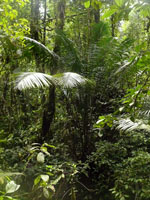
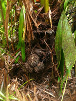
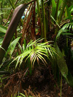
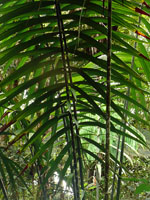
| Field notes | Solitary understory palm. Acaulecent. Roots few visible. Leaves 9; sheath 102 cm long, 22.7 cm wide apically, open; petiole 245 cm long, 3 cm wide, green, section round; rachis 370 cm long; lamina pinnate; pinnae 49 per side, regularly inserted; basal pinna 69 cm long, 4.5 cm wide, middle pinna 76 cm long, 6 cm wide, apical pinna 12 cm long, 1.8 cm wide. Infructescence interfoliar, globose. Fruits 3, to 10 cm wide, covered with woody pyramidal protuberances. Local name: Cabecita. Uses: the petioles are split and used for weaving small baskets. Silica gel sample taken. Transect: HB 1048 |

|
 Other records of Ammandra decasperma