| Collector | Galeano, G. |
| Number | 8165 |
| Collected with | H. Balslev, I.L. Olivares, J. Carreño, J.C. Copete, D. Jiménez, S. Valenciá & L.A. Núñez |
| Country | Colombia |
| Subpart | Valle del Cauca |
| County | |
| Locality | 32 km NW of Buenaventura, 15 km NNE of Bahía Málaga naval base. La Plata. Sitio El Corozal. Wet tropical rainforest on hills behind mangrove. |
| Coordinates | 4° 5' 25.764'' N 77° 16' 6.402'' W |
| Minimum elevation (m) | 45 |
| Maximum elevation (m) | 45 |
| Start date | 2011/08/18 |
| End date | 2011/08/18 |
| Family | Arecaceae |
| Identification | Bactris coloradonis L.H.Bailey |
| Determined by | G.Galeano (COL) & H.Balslev (AAU) |
| Identification qualifier | |
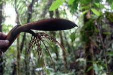
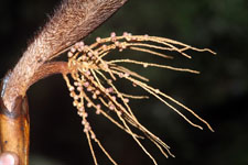
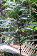
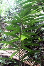
| Field notes | Colonial understory palm. Stems 2-3 m high, 3.5-4 cm thick, smooth. Roots few visible. Leaves 8 per stem; sheath 40 cm long, open; petiole 68 cm long, section round, with 5 cm long black spines; rachis 127 cm long; lamina pinnate, bushy; pinnae 17 per side, irregularly inserted in groups of 2-3; basal pinna 36 cm long, 4 cm wide, middle pinna 41 cm long, 5 cm wide. Silica gel sample taken. Transect: HB 1047, subunit no. 61 |
|
 Other records of Bactris coloradonis