| Collector | Galeano, G. |
| Number | 8162 |
| Collected with | H. Balslev, I.L. Olivares, J. Carreño, J.C. Copete, D. Jiménez, S. Valenciá & L.A. Núñez |
| Country | Colombia |
| Subpart | Valle del Cauca |
| County | |
| Locality | 32 km NW of Buenaventura, 15 km NNE of Bahía Málaga naval base. La Plata. Sitio El Corozal. Wet tropical rainforest on hills behind mangrove. |
| Coordinates | 4° 5' 25.764'' N 77° 16' 6.402'' W |
| Minimum elevation (m) | 45 |
| Maximum elevation (m) | 45 |
| Start date | 2011/08/18 |
| End date | 2011/08/18 |
| Family | Arecaceae |
| Identification | Chelyocarpus dianeurus (Burret)H.E.Moore |
| Determined by | G.Galeano (COL) & H.Balslev (AAU) |
| Identification qualifier | |
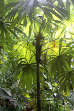
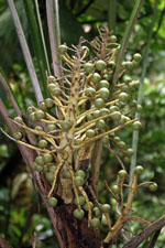
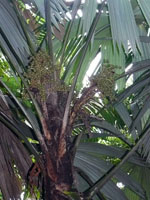
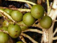
| Field notes | Solitary understory palm. Stem 1.24 m high, 10 cm wide, smooth. Roots few visible. Leaves 17; sheath 31 cm long, open, covered with yellowish silky wool; petiole 146 cm long; lamina palmate, 149 cm long, 153 cm wide, flat, white below. Infructescence interfoliar; prophyll 10 cm long, 4 cm wide, herbaceous; peduncle 21 cm long, 3 cm wide; rachis 34 cm long; rachillae 35, 2.5-20 cm long. Fruits yellow, 2 cm long, 2.5 cm wide. Silica gel sample taken. Transect: HB 1047 |
|