| Collector | Galeano, G. |
| Number | 8155 |
| Collected with | H. Balslev, I.L. Olivares, J. Carreño, J.C. Copete, D. Jiménez, S. Valenciá & L.A. Núñez |
| Country | Colombia |
| Subpart | Valle del Cauca |
| County | |
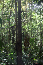
| Locality | 24 km NW of Buenaventura, 18 km ENE of Bahía Málaga naval base. La Plata. Sitio El Divorcio. Wet tropical rainforest on hills behind mangrove. |
| Coordinates | 4° 3' 41.136'' N 77° 11' 37.798'' W |
| Minimum elevation (m) | 17 |
| Maximum elevation (m) | 17 |
| Start date | 2011/08/17 |
| End date | 2011/08/17 |
| Family | Arecaceae |
| Identification | Wettinia radiata (O.F.Cook & Doyle) R.Bernal |
| Determined by | G.Galeano (COL) & H.Balslev (AAU) |
| Identification qualifier | |
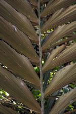
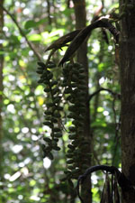
| Field notes | Solitary palm. Stem 4 m long, 9.5 cm thick. Stilt roots 12, 2.5m long, 4 cm thick. Crownshaft 1.3 m long. Leaves 8; sheath 1.29 m long, closed, dark green; petiole 93 cm long; rachis 3.57 m long; lamina pinnate; pinnae 12 per side, regularly inserted, each pinna divided to the base into 4-7 segments; basal pinna 51 cm long, middle pinna 71 cm long, apical pinna 36 cm long. Infructescence infrafoliar; peduncular bract brown; peduncle 20 cm long; rachis 3 cm long; rachillae 5, 40-42 cm long. Fruits yellow, 3.5 cm long, 2 cm wide. Transect: HB 1046 |
.jpg)
.jpg)
|
 Other records of Wettinia radiata