AAU Herbarium Database |
| New Search Modify Search |
| Collector | Galeano, G. |
| Number | 8151 |
| Collected with | H. Balslev, I.L. Olivares, J. Carreño, J.C. Copete, D. Jiménez, S. Valenciá & L.A. Núñez |
| Country | Colombia |
| Subpart | Valle del Cauca |
| County | |
| Locality | 24 km NW of Buenaventura, 18 km ENE of Bahía Málaga naval base. La Plata. Sitio El Divorcio. Wet tropical rainforest on hills behind mangrove. |
| Coordinates | 4° 3' 41.136'' N 77° 11' 37.798'' W |
| Minimum elevation (m) | 17 |
| Maximum elevation (m) | 17 |
| Start date | 2011/08/17 |
| End date | 2011/08/17 |
| Family | Arecaceae |
| Identification | Bactris barronis L.H.Bailey |
| Determined by | G.Galeano (COL) & H.Balslev (AAU) |
| Identification qualifier | |
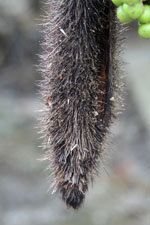
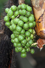
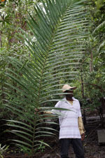
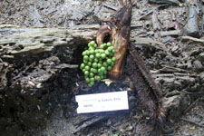
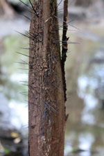
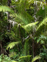
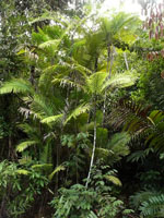
| Field notes | Cespitose midstory palm. Stem 3-5 m high, 7-8 cm thick, smooth, grayish-brown. Leaves 7-8 per stem; sheath 68 cm long, open, with 5-10 cm long black spines; petiole 52 cm long, section round; rachis 3.35 m long, without spines; lamina pinnate; pinnae 46 per side, insertion regular; basal pinna 61 cm long, 5 cm wide, middle pinna 76 cm long, 5.5 cm wide, apical pinna 44 cm long, 3.5 cm wide. Infructescence infrafoliar; prophyll 24 cm long, 6 cm wide, woody; peduncular bract 33 cm long, brown, with 0.7-2 cm long brown to black spines; peduncle 12 cm long, 1.5 cm wide, without spines; rachis 16 cm long, without spines; rachillae more than 30, 1.5-4 cm long. Fruits 1 cm long, 1.5 cm wide, with 0.2 mm long black spines. Silica gel sample taken. Transect: HB 1046 |
| |
 Other records of Bactris barronis Other records of Bactris barronisThe map displays only records from the Aarhus Herbarium Database. The records may not represent the full distribution of Bactris barronis |
| New Search Modify Search |