| Collector | Davidse, G. |
| Number | 28515 |
| Collected with | G. Herrera Ch., M.H.Grayum |
| Country | Costa Rica |
| Subpart | Puntarenas |
| County | |
| Locality | Cordillera de Talamanca; area around Río Canasta, 9.5 airline km NW of Agua Caliente, between Cerro Frantzius and Cerro Pittier. Lower montane wet forest with a few pasture clearings. |
| Coordinates | 9° 2' N 82° 59' W |
| Minimum elevation (m) | 1500 |
| Maximum elevation (m) | 1600 |
| Start date | 1984/09/06 |
| End date | 1984/09/06 |
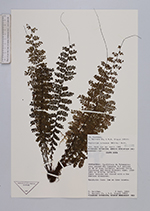
| Family | Aspleniaceae |
| Identification | Asplenium rutaceum (Willd.)Mett. |
| Determined by | H.v.d.Werff |
| Identification qualifier | |
| Field notes | Epiphytic fern, low on tree trunks. |
|