AAU Herbarium Database |
| New Search Modify Search |
| Collector | Congdon, G. |
| Number | 734 |
| Collected with | |
| Country | Thailand |
| Subpart | |
| County | |
| Locality | Tarutao National Park. Limestone along Malacca Creek. |
| Coordinates | |
| Minimum elevation (m) | 0 |
| Maximum elevation (m) | 0 |
| Start date | 1980/07/01 |
| End date | 1980/07/01 |
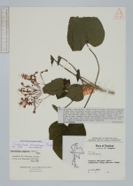
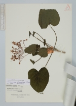
| Family | Lamiaceae |
| Identification | Clerodendrum intermedium Cham. |
| Determined by | C. Leeratiwong |
| Identification qualifier | |
| Field notes | Shrublet stem square, white hairs at nodes; lvs below densely dotted with disc-like glands; inflorescence terminal, reddish hairy; clayx tube 2mm, lobes 3.5mm, red, glandular hairy outside and inside; corolla tube 1.5cm, orange, hairy, lobes 6-7mm x 3mm; stamens extend 3cm beyond tube; style 2 cm beyond tube, tip bifid; very local on limestone rocks near the sea. Red sepals clasping mature fruit (Juli 30) |
| |
| This record has no coordinates. Display map with the 6 georeferenced records of Clerodendrum intermedium in the AAU Herbarium Database. |
| New Search Modify Search |