AAU Herbarium Database |
| New Search Modify Search |
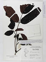
| Collector | Congdon, G. |
| Number | 515 |
| Collected with | |
| Country | Thailand |
| Subpart | |
| County | |
| Locality | Tarutao National Park. Trail from Talo Oo Dang to Malacca Creek |
| Coordinates | |
| Minimum elevation (m) | 1 |
| Maximum elevation (m) | 100 |
| Start date | 1980/03/27 |
| End date | 1980/03/27 |
| Family | Leeaceae |
| Identification | Leea indica Merr. |
| Determined by | P.C. van Welzen |
| Identification qualifier | |
| Field notes | Tree to 3m; corymbs to 25 cm accross; sepals 5, green, petals 5, pale green, valvate, recurved; stamens 5, immersed in fleshy yellow disc, anthers connate, purple, appendaged; ovary 6-celled, 1 ovule/cell; common in secondary forest |
| |
| This record has no coordinates. Display map with the 27 georeferenced records of Leea indica in the AAU Herbarium Database. |
| New Search Modify Search |