AAU Herbarium Database |
| New Search Modify Search |
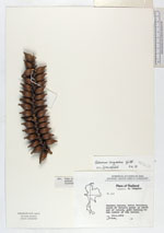
| Collector | Congdon, G. |
| Number | 264 |
| Collected with | |
| Country | Thailand |
| Subpart | Satun |
| County | |
| Locality | Tarutao Island, Satun Province south of Malice creek on north end of island, path leading to the center of the island |
| Coordinates | |
| Minimum elevation (m) | 1 |
| Maximum elevation (m) | 100 |
| Start date | 1979/02/18 |
| End date | 1979/02/18 |
| Family | Arecaceae |
| Identification | Calamus longisetus Griff. |
| Determined by | Dransfield |
| Identification qualifier | |
| Field notes | Palm to 8 m, compound leaves 6 m long with sharp prickles in groups along midrib, fruit brown, scaly, prndulous in racemes of spikes, thorns clustered at nodes, reportedly edible, 2 km inland |
| |
| This record has no coordinates. Display map with the 9 georeferenced records of Calamus longisetus in the AAU Herbarium Database. |
| New Search Modify Search |