AAU Herbarium Database |
| New Search Modify Search |
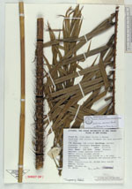
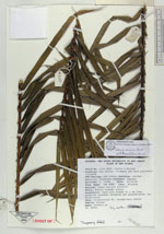
| Collector | Frodin, |
| Number | 3190 |
| Collected with | Morren |
| Country | Papua New Guinea |
| Subpart | Sandaun |
| County | |
| Locality | Hak Valley; findspot not more precisely recorded UTM Easting: 54M 568865 Northing: 9457845 District Telefomin. Lower montane forest?? Habit: Fairly slender rattan |
| Coordinates | |
| Minimum elevation (m) | 900 |
| Maximum elevation (m) | 900 |
| Start date | 1993/10/27 |
| End date | 1993/10/27 |
| Family | Arecaceae |
| Identification | Calamus eximius Burret |
| Determined by | Dransfield,J. |
| Identification qualifier | |
| Field notes | Palm-like fronds to 1.9m long; pinnules somewhat drooping and greyish-green (no glossiness) Uses: Construction #1, Bridge main cables |
| |
| This record has no coordinates. Display map with the 1 georeferenced records of Calamus eximius in the AAU Herbarium Database. |
| New Search Modify Search |