AAU Herbarium Database |
| New Search Modify Search |
| Collector | Skov, F. |
| Number | 64834 |
| Collected with | Borchsenius, F. & Blicher-Mathiesen, U. & Klitgaard, B. B. |
| Country | Ecuador |
| Subpart | AZUAY |
| County | |
| Locality | Naranjal - Machala road, 33 km from Machala and 6 km E along trail (Río Bonito). Timber trail leading into the forest. Moist disturbed tropical forest |
| Coordinates | 3° 4' S 79° 45' W |
| Minimum elevation (m) | 400 |
| Maximum elevation (m) | 400 |
| Start date | 1987/11/18 |
| End date | 1987/11/18 |
| Family | Arecaceae |
| Identification | Geonoma lanata A.J. Hend., Borchs. & Balslev |
| Determined by | A.Henderson |
| Identification qualifier | |
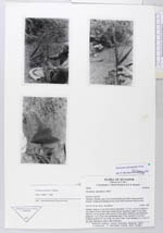
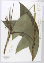
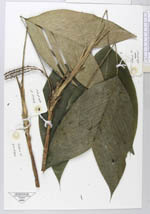
| Field notes | Solitary. Stem to 1.5 m, 0.8 cm diam, internodes 1-1.5 cm. Leaves 8, sheath 4.5 cm; petiole 19 cm, 3 mm wide, rounded below, flat above; rachis 14 cm; blade intire 23 x 16 cm, plicate. Inflorescence 2-3 per plant, interfoliar, once branched; prophyll 11 cm, 0.8 cm wide; peduncular bract 17 cm, inserted 5.5 cm above prophyll; peduncle 10 cm; rachis very short 2 mm- 5 cm; rachillae 2-3, 12 cm, 0.3 cm wide, light green, with a white tomentum. |
| |
 Other records of Geonoma lanata Other records of Geonoma lanataThe map displays only records from the Aarhus Herbarium Database. The records may not represent the full distribution of Geonoma lanata |
| New Search Modify Search |