AAU Herbarium Database |
| New Search Modify Search |
| Collector | Skov, F. |
| Number | 64833 |
| Collected with | Borchsenius, F. & Blicher-Mathiesen, U. & Klitgaard, B. B. |
| Country | Ecuador |
| Subpart | AZUAY |
| County | |
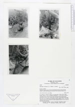
| Locality | Naranjal - Machala road, 33 km from Machala and 6 km E along trail (Río Bonito). Timber trail leading into the forest. Moist disturbed tropical forest |
| Coordinates | 3° 4' S 79° 45' W |
| Minimum elevation (m) | 400 |
| Maximum elevation (m) | 400 |
| Start date | 1987/11/18 |
| End date | 1987/11/18 |
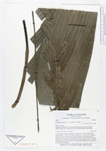
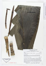
| Family | Arecaceae |
| Identification | Geonoma cuneata var. cuneata H.Wendl. ex Spruce |
| Determined by | F. Skov (AAU), 1989. |
| Identification qualifier | |
| Field notes | Solitary. Stem to 1.5 m, 2.5 cm diam, internodes 0.5 -1 cm. Leaves 9; sheath of lower leaf 12 cm, 4 cm wide, open to base, persistent and decaying on stem; petiole 60 cm, 0.8 cm wide, rounded below, flat above, green; rachis 56 cm; blade entire, 80 x 32 cm. Inflorescence interfoliar, spicate; prophyll 13 cm, 1.5 cm wide; peduncular bract 18 cm, inserted 0.5 cm above prophyll; peduncle 16 cm; rachis 22 cm, 0.9 cm wide, deep red. |
| |
| Display all 31 georeferenced records of Geonoma Geonoma cuneata var. cuneata |
| New Search Modify Search |