AAU Herbarium Database |
| New Search Modify Search |
| Collector | Skov, F. |
| Number | 64820 |
| Collected with | Borchsenius, F. & Klitgaard, B. B. |
| Country | Ecuador |
| Subpart | ESMERALDAS |
| County | |
| Locality | New road from Lita towards San Lorenzo, 15 - 18 km from Lita. Disturbed montane forest close to road |
| Coordinates | 0° 50' N 78° 34' W |
| Minimum elevation (m) | 900 |
| Maximum elevation (m) | 900 |
| Start date | 1987/11/11 |
| End date | 1987/11/11 |
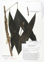
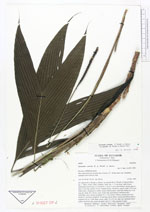
| Family | Arecaceae |
| Identification | Geonoma cuneata var. gracilis (H.A. Wendl. ex Spruce)Skov |
| Determined by | F. Skov (AAU) 1989. |
| Identification qualifier | |
| Field notes | Solitary. Stem 1m, 1-1.5 cm diam, light brown; internodes1 cm at base, 2-3 cm above. Leaves 9, erect and arching; sheath open to base, 6 cm long; petiole 18 cm, rounded below, flat above, green; rachis 12-14 cm; blade entire, triangular in outline, deeply bifid at apex, each half ending in a 3 cm long tip, blade 30 x 20 cm, veins 14 per side, pronounced. Infructescence interfoliar, erect, spicate; prophyll 10 x 7 cm, brown, fibrous; peduncular bract inserted 3 cm above prophyll, 20 cm long, green below, brown and fibrous above; peduncle 46 cm, 3 mm diam, green; spike 15 x 0.5 cm, dark red; immature fruits yellow on lower side, green on upper side, 8 x 7 mm, pointed at apex. |
| |
 Other records of Geonoma cuneata var. gracilis Other records of Geonoma cuneata var. gracilisThe map displays only records from the Aarhus Herbarium Database. The records may not represent the full distribution of Geonoma cuneata var. gracilis |
| New Search Modify Search |