AAU Herbarium Database |
| New Search Modify Search |
| Collector | Skov, F. |
| Number | 64805 |
| Collected with | Borchsenius, F. & Blicher-Mathiesen, U. |
| Country | Ecuador |
| Subpart | NAPO |
| County | |
| Locality | East bank of Río Yasuní, 2 km downstream from the outlet from Laguna Jotun Cocha. Trail leading into the forest. Tropical rainforest |
| Coordinates | 0° 59' S 75° 27' W |
| Minimum elevation (m) | 250 |
| Maximum elevation (m) | 250 |
| Start date | 1987/11/07 |
| End date | 1987/11/07 |
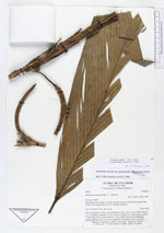
| Family | Arecaceae |
| Identification | Geonoma stricta var. stricta (Poit.)Kunth |
| Determined by | |
| Identification qualifier | |
| Field notes | Stem to 1 m, 1 cm diam, internodes 1.5 cm. Leaves 8; sheath 4 cm, open to base; petiole 17 cm; rachis 44 cm, blade entire 60 x 15 cm. Inflorescence inter-infrafoliar, spicate; prophyll 6 cm, 1 cm wide; peduncle 5 cm; rachis 13 cm, 1 cm wide. |
| |
| Display all 90 georeferenced records of Geonoma Geonoma stricta var. stricta |
| New Search Modify Search |