AAU Herbarium Database |
| New Search Modify Search |
| Collector | Skov, F. |
| Number | 64800 |
| Collected with | Borchsenius, F. & Blicher-Mathiesen, U. |
| Country | Ecuador |
| Subpart | NAPO |
| County | |
| Locality | "Where the outlet from laguna Jotun Cocha meets Río Yasuní; on southern bank of outlet. Swamp forest close to river" |
| Coordinates | 0° 59' S 75° 27' W |
| Minimum elevation (m) | 250 |
| Maximum elevation (m) | 250 |
| Start date | 1987/11/07 |
| End date | 1987/11/07 |
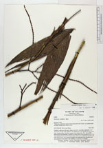
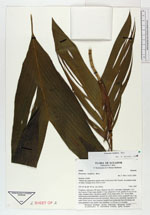
| Family | Arecaceae |
| Identification | Geonoma laxiflora Mart. |
| Determined by | H. Balslev |
| Identification qualifier | |
| Field notes | Cespitose, with up to 40 stems. Stem to 3 m, 0.5-1 cm diam; internodes 1-5.5 cm. Leaves 5-9 per stem; sheath 4-7 cm, closed for 1.5 cm; petiole 12 cm, 0.3 cm wide, rounded below, flat above; rachis 14 cm; blade entire, 30 x 16 cm, bifid. Inflorescence bud infrafoliar, inserted two nodes below crown; prophyll 4 cm, 1 cm wide; peduncular bract enclosed in prophyll. Inflorescence infrafoliar, inserted to 12 nodes below crown, once branched; prophyll and peduncular bract deciduous, not seen; peduncle 4 cm; rachis 3 cm; rachillae 4, to 20 cm, 0.3 cm diam. |
| |
 Other records of Geonoma laxiflora Other records of Geonoma laxifloraThe map displays only records from the Aarhus Herbarium Database. The records may not represent the full distribution of Geonoma laxiflora |
| New Search Modify Search |