AAU Herbarium Database |
| New Search Modify Search |
| Collector | Skov, F. |
| Number | 64793 |
| Collected with | Borchsenius, F. & Blicher-Mathiesen, U. |
| Country | Ecuador |
| Subpart | NAPO |
| County | |
| Locality | Pañacocha. North bank of Río Napo, 2 km NW of village. Swamp forest on edge of cattle field |
| Coordinates | 0° 26' S 76° 4' W |
| Minimum elevation (m) | 250 |
| Maximum elevation (m) | 250 |
| Start date | 1987/11/05 |
| End date | 1987/11/05 |
| Family | Arecaceae |
| Identification | Geonoma macrostachys var. macrostachys Mart. |
| Determined by | F. Skov (AAU) 1989. |
| Identification qualifier | |
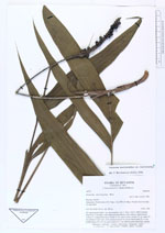
| Field notes | Solitary. Stem 8 m, 3 cm diam, with numerous adventitious roots (almost subterranean). Leaves 11, congested at base; sheath 11 cm, open to base; petiole 21 cm; rachis 36 cm; pinnae 4-5 per side, lower pinna decurrent for 14 cm; basal pinna 21 x 4 cm, middle pinna 18 x 4.5 cm, apical pinna 9 x 7 cm. Inflorescence interfoliar, spicate. |
| |
| Display all 220 georeferenced records of Geonoma Geonoma macrostachys var. macrostachys |
| New Search Modify Search |