AAU Herbarium Database |
| New Search Modify Search |
| Collector | Skov, F. |
| Number | 64762 |
| Collected with | Borchsenius, F. |
| Country | Ecuador |
| Subpart | NAPO |
| County | |
| Locality | Road from Archidona to Tena, km 4 from Archidona, 1 km W of road, steep hill. Slightly disturbed forest on hill slopes and plateau |
| Coordinates | 0° 55' S 77° 50' W |
| Minimum elevation (m) | 800 |
| Maximum elevation (m) | 800 |
| Start date | 1987/10/21 |
| End date | 1987/10/21 |
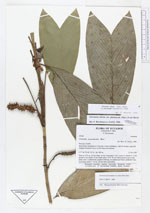
| Family | Arecaceae |
| Identification | Geonoma stricta var. piscicauda (Dammer)A.J.Hend. |
| Determined by | H. Balslev |
| Identification qualifier | |
| Field notes | Stem to 130 cm, 0.6 cm diam, brown, internodes 3 cm. Leaves 5; sheath 2 - 3 cm; petiole 9 cm; rachis 19 cm; blade entire, 25 X 10 cm. inflorescences up to 2 per plant, inter- to infrafoliar; prophyll missing, no peduncular bracts; peduncle 5 cm, recurving; rachis 7 - 8 cm, 0.8 cm wide, horizontal. |
| |
| Display all 75 georeferenced records of Geonoma Geonoma stricta var. piscicauda |
| New Search Modify Search |