AAU Herbarium Database |
| New Search Modify Search |
| Collector | Skov, F. |
| Number | 64756 |
| Collected with | Borchsenius, F. |
| Country | Ecuador |
| Subpart | NAPO |
| County | |
| Locality | Cordillera de Huacamayos. Baeza - Tena road, km 32 from Baeza. Secondary, montane forest on slope close to road |
| Coordinates | 0° 41' S 77° 52' W |
| Minimum elevation (m) | 2100 |
| Maximum elevation (m) | 2100 |
| Start date | 1987/10/20 |
| End date | 1987/10/20 |
| Family | Arecaceae |
| Identification | Geonoma orbignyana subsp. orbignyana Mart. |
| Determined by | A. Henderson |
| Identification qualifier | |
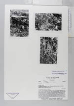
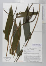
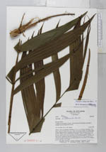
| Field notes | Solitary. Stem procumbent or bending, to 1 m, 1-1.5 cm diam; internodes 1 cm, green. Leaves 6, young leaves erect, older ones arching; sheath 7 cm, open to base, margins slightly fibrous, old sheaths often persistent after leaf-fall; petiole 44-48 cm, 0.5 cm diam, green, rounded below, flat above; rachis 27-30 cm; pinnae 3-6 per side. Inflorescence infra to interfoliar, once branched; prophyll 13-19 cm, 1 cm wide at base, chartaceous, persistent; peduncular bract 13-18 cm, inserted 8-10.5 cm above prophyll, chartaceous, persistent; peduncle 28 cm; rachis 2 cm; rachillae 4, to 15 cm long, 0.3 cm diam. |
| |
 Other records of Geonoma orbignyana subsp. orbignyana Other records of Geonoma orbignyana subsp. orbignyanaThe map displays only records from the Aarhus Herbarium Database. The records may not represent the full distribution of Geonoma orbignyana subsp. orbignyana |
| New Search Modify Search |