AAU Herbarium Database |
| New Search Modify Search |
| Collector | Skov, F. |
| Number | 64713 |
| Collected with | Borchsenius, F. & Skov-Petersen, K. |
| Country | Ecuador |
| Subpart | MORONA-SANTIAGO |
| County | |
| Locality | Plan de Milagro - Gualaceo road, 2 km from Plan de Milagro. Secondary forest |
| Coordinates | 3° 1' S 78° 30' W |
| Minimum elevation (m) | 1850 |
| Maximum elevation (m) | 1850 |
| Start date | 1987/09/25 |
| End date | 1987/09/25 |
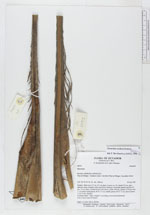
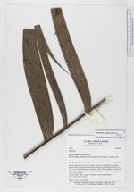
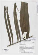
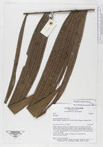
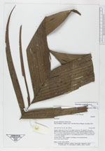
| Family | Arecaceae |
| Identification | Geonoma undata Klotzsch |
| Determined by | Borchsenius, F. (AAU), 1996. |
| Identification qualifier | |
| Field notes | Solitary. Stem up to 5.0 m, 4 5 cm diam. Leaves ca. 15; sheath 35 cm, open almost to base, margins with long fibers forming a reticulate pattern; petiole 50 cm, 1.0 cm wide, rounded below, flat above; rachis 108 cm; pinnae ca 20 per side, 1 - 6 veined; basal pinnae 46 X 5.5 cm; middle pinnae 46 X 11 cm; apical pinnae 31 X 11 cm. (Sterile) Common name: "Baja colapato" according to two local informants. Uses: Leaves used for thatch. Dubl.: 3: AAU, QCA, QCNE. |
| |
| Display all 75 georeferenced records of Geonoma Geonoma undata |
| New Search Modify Search |