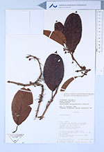
| Collector | Hurtado, F. |
| Number | 449 |
| Collected with | Angel Alvarado |
| Country | Ecuador |
| Subpart | Napo |
| County | |
| Locality | 3 km este del Caserío de Huamaní. Al norte de la carretera Hollín- Loreto, por una trocha. Bosque pluvial Premontano. |
| Coordinates | 0° 43' S 77° 36' W |
| Minimum elevation (m) | 1200 |
| Maximum elevation (m) | 1200 |
| Start date | 1988/09/17 |
| End date | 1988/09/19 |
| Family | Dilleniaceae |
| Identification | Doliocarpus novogranatensis Kubitzki |
| Determined by | G. Aymard |
| Identification qualifier | |
| Field notes | Bejuco en un copal caído en la carretera Hollín-Loreto a 1300 m al NW de Huamaní. Frutos redondeados verdes con cáliz persistente rojo. |
|
 Other records of Doliocarpus novogranatensis