AAU Herbarium Database |
| New Search Modify Search |
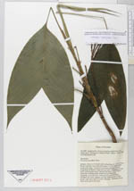
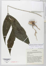
| Collector | Borchsenius, F. |
| Number | 42 |
| Collected with | |
| Country | Ecuador |
| Subpart | EL ORO |
| County | |
| Locality | Sambotambo, along road going north 8 km W of Piñas, km 6. Remnants of tropical forest |
| Coordinates | 3° 35' S 79° 49' W |
| Minimum elevation (m) | 1200 |
| Maximum elevation (m) | 1200 |
| Start date | 1992/12/19 |
| End date | 1992/12/19 |
| Family | Arecaceae |
| Identification | Geonoma lanata A.J. Hend., Borchs. & Balslev |
| Determined by | A.Henderson |
| Identification qualifier | |
| Field notes | Solitary. Stem to 1.5 m tall, erect or bending, ca. 1 cm in diam., brown, smooth, very hard; internodes 1-1.5 cm apart, nodes consicuous rings. Leaves 6-9, erect and arching, entire og irregularly divided in 2 segments per side. Inflorescence buds erect, with prophyll and 1 peduncular bract. Inflorescence interfoliar, arching, green; infructescence becoming infrafoliar, recurved, red. Inflorescence only branches; rachillae 3-4, strict, slightly curving, with flowers in 8/3 spiral, with three lines of white indument. Immature fruits ovate-acute, green, 8 x 6 mm |
| |
 Other records of Geonoma lanata Other records of Geonoma lanataThe map displays only records from the Aarhus Herbarium Database. The records may not represent the full distribution of Geonoma lanata |
| New Search Modify Search |